

 QPF
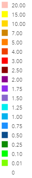 
Current Droughts Data
Current radar:
Toggle this button to add and remove radar imagery from the map. The radar information is provided by Iowa Environmental Mesonet at Iowa State University. The radar images are updated every 5 minutes.
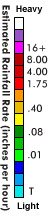
QPF:
Toggle this button to add and remove radar imagery from the map. The QPF data is provided by NOAA National Centers for Environment Information. The QPF images are updated every 24 hours.
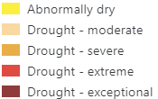
Drought:
Toggle this button to add and remove soil moisture information from the map. The Shallow Soil Moisture overlay displays the estimated relative moisture content (%) of the upper 10cm of soil. Data is from the National Aeronautics and Space Administration (NASA). The overlay is updated daily from the NLDAS-NOAH Land Surface model.
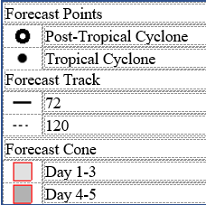
Hurricane:
Toggle this button to add and remove radar imagery from the map. The QPF data is provided by NOAA National Centers for Environment Information. The Hurricane images are updated every 24 hours. |
 Pop Up
 Refresh
 Zoom On Site